
Are you looking to share your travel experiences in an engaging and interactive way? Interactive travel maps are an excellent way to showcase your journeys, allowing you to plot destinations, add photos, videos, and notes, and share them with friends, family, or your online audience.
Google Maps is the undisputed leader in digital mapping. With its large database of locations, street views for navigating through unfamiliar streets, and real-time traffic updates, it offers convenience and accessibility for travelers worldwide. Easily embed interactive maps straight from Google Maps into your posts, allowing your audience to follow your journeys effortlessly.
However, it’s essential to acknowledge its limitations, including restricted customization options and potential privacy concerns. To overcome these challenges, consider exploring alternative map-making tools that offer colorful, customized, and interactive solutions.
Google Maps
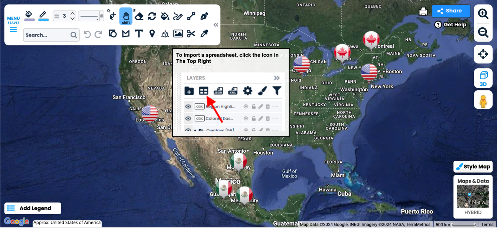
Google Maps is a powerful tool for creating interactive travel maps that can enhance your travel blog. You can easily plot your journey, mark significant locations, and even embed the map directly into your posts. To create your interactive map, simply go to Google Maps, click “Saved,” and then select a place to start a new map. You can add layers, draw routes, and include notes and media for each location.
Embedding the map is straightforward: just click on the “Share” button and copy the embed code to integrate it seamlessly into your website. While Google Maps is feature-rich, it does have limitations in customization and design, so it’s worth considering other options for more tailored solutions.
Travellerspoint
Travellerspoint brings exciting differences to the way you document your travels. Using their platform, you can seamlessly map out your latest adventures, adding images and short blog posts to each destination marker as well. With this tool, you are also able to plan out an itinerary map.
Once you have created your map, it’s really simple to copy the embed code onto your own blog for your audience to explore. The platform is open and free for anyone to use. All you have to do is sign up. It’s a fantastic opportunity for travel bloggers to incorporate an interactive way for their readers to follow them on their adventures.
TravelMap
TravelMap offers a seamless solution for documenting past, present, and future trips. Attach photos, videos, and articles to your personalized map, sharing your experiences with ease through a simple link. At its root, TravelMap maintains its simplicity and self-sufficiency and thrives on its user-friendly design. Separate maps by continents, countries, or states to offer users an immersive browsing experience, then customize colors and interactions to suit your branding and content strategy.


Scribble Maps
With Scribble Maps, unleash your creativity by sketching and sharing personalized maps effortlessly. Add custom images and text overlays, draw boundaries, and calculate distances with ease. Whether you’re tracing your route or highlighting must-visit landmarks, Scribble Maps offers a user-friendly canvas to bring your vision to life.
PictraMap
PictraMap redefines the process of sharing travel memories with its innovative animated maps that inspire an audience. This free web-based tool allows you to create dynamic maps within minutes, showcasing your adventures in a unique and captivating way. With customizable options galore and effortless sharing capabilities, their maps stand out as the go-to platform for passionate travelers eager to share their stories with the world.
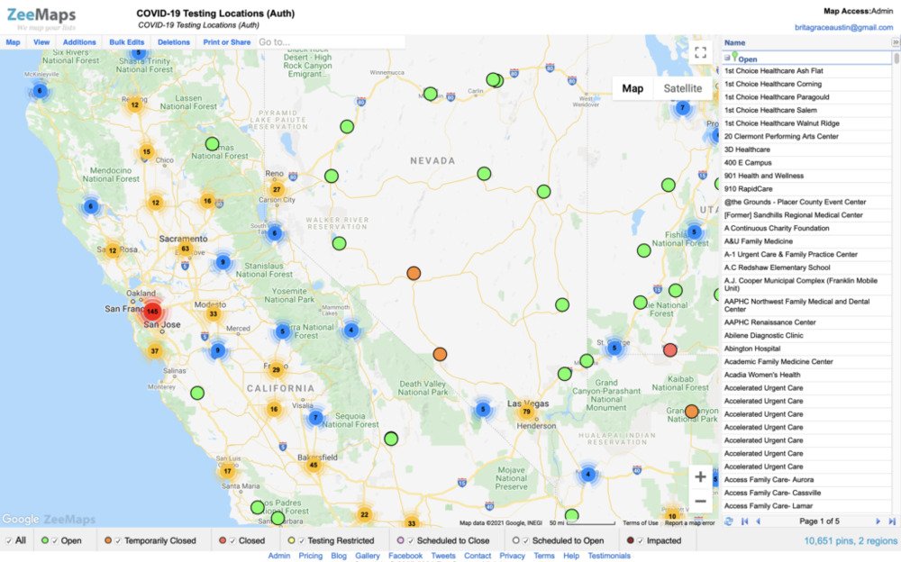
ZeeMaps
Experience the freedom of map creation without constraints with ZeeMaps. Customize markers, spotlight regions, and enrich your locations with multimedia content. Engage your audience with explanatory videos or immersive audio clips, creating an interactive journey that captivates and informs.
Want to increase traffic to your pages? Click here to view our on-page optimization packages
MapTiler
MapTiler is definitely one of the more advanced map makers on our list and is definitely one with more features. It is used by NASA, Google, and Apple. You can effectively render the geodata into the map tiles which are suitable for Google Maps API mashups, Google Earth, and many others.
One of it’s best features is being able to build your own 3D map. You can create a realistic 3D map of the world and include roads and placenames for context. You are able to use MapTiler on Windows, Linux, and Mac, which makes this tool incredibly versatile. There is a free version that you can try out, as well as paid versions that offer different bundles and features.
HeatmapTool
Experience the power of data visualization with HeatmapTool.com, the ultimate solution for creating stunning heat maps. It’s perfectly integrated with the Google Maps API, which allows you to transform spatial data into vibrant visual representations with ease. Simply upload your CSV file containing latitude, longitude, and optional amplitude data, customize your preferences, and receive your personalized heat map image within seconds.
With its user-friendly interface and powerful features, this interactive map tool stands out as the go-to choice for anyone seeking to visualize their data accurately for their audience.
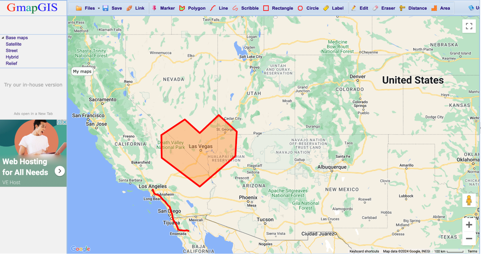
GmapGIS
GmapGIS offers a straightforward solution for mapping enthusiasts. Draw lines, annotate landmarks, and measure distances without the need for a Google account. Share your creations effortlessly with automated links, enhancing your website or blog with interactive visual aids. Filter and customize your maps to suit your audience’s needs, sharing your insights with the world through seamless embedding options.
Enhance Your Travel Blog with Interactive Maps Plugins
Elevate your travel blog using plugins like MapGeo and Interactive World Maps. Easily create customized maps with regions, colored markers, and interactive features. Choose from a wide selection of vector maps, including world maps, continents, countries, and states. Add tooltips, actions, and customizations to engage your audience effectively.
Seamlessly embed maps into posts, pages, or widgets using shortcodes or PHP functions. With responsive designs and cross-device compatibility, these plugins ensure stunning visuals on any screen. These plugins offer versatile solutions for creative expression and data visualization to captivate your audience with compelling storytelling, no matter the niche of your blog.
Incorporating these powerful map-making tools into a travel blog can elevate storytelling and captivate audiences with compelling visual narratives. By leveraging plugins like MapGeo and Interactive World Maps, bloggers can enhance their blogs with customizable maps and interactive features, driving engagement and fostering a sense of exploration and discovery.
Want to increase traffic to your pages? Click here to view our on-page optimization packages

Matt is a travel entrepreneur with over a decade of experience across digital marketing, operations, and asset investment. His ventures include founding the agency Travel Tractions, successfully buying and selling multiple travel websites, and owning a boutique hotel in his home base of Cape Town. His writing focuses on the intersection of data-driven marketing and real-world business growth in the tourism sector.